10 Abandoned Railroad Trails Now America’s Most Beautiful Hikes

Steel rails that once carried the hum of locomotives now lie silent, transformed into paths that pull you into landscapes both wild and tender. Each step echoes history while opening doors to forests, rivers, and valleys that feel untouched yet intimately familiar.
You can hear the whisper of the wind through abandoned tunnels, feel the gentle slope beneath your feet, and watch sunlight spill across bridges that once carried trains.
These trails aren’t just hikes—they’re journeys through time and scenery, where solitude meets discovery, and every mile tells a story you won’t soon forget.
1. Great Allegheny Passage — Pennsylvania & Maryland
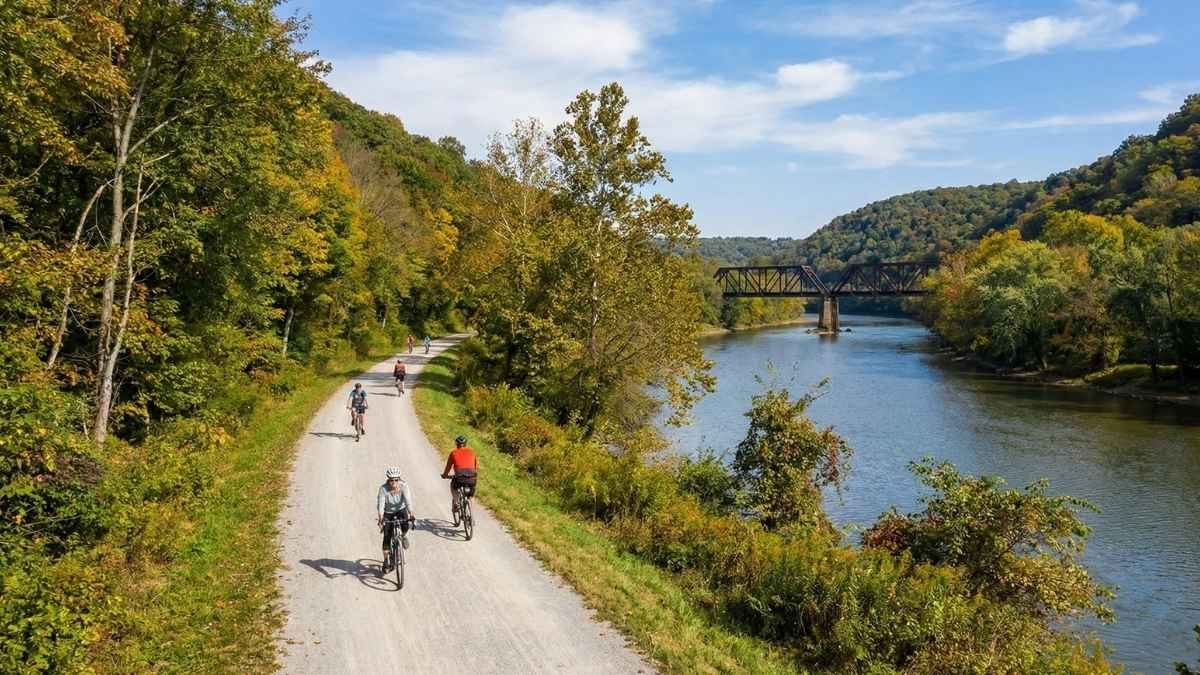
The Great Allegheny Passage (GAP) is arguably the crown jewel of American rail‑to‑trail hikes and one of the most beloved long‑distance routes in the country. Stretching roughly 150 miles between Pittsburgh, PA, and Cumberland, MD, this trail follows the gentle grades of former railroad corridors through sweeping river valleys, dense forests, rolling farmland, and historic towns. The crushed‑limestone path makes it an easy walk for most hikers while still feeling wild and remote at times. Every mile seems to reveal another scenic vista — whether it’s the rural charm of Ohiopyle State Park or the serene shores of the Casselman River. Wikipedia+1
What sets the GAP apart from many other rail trails is how living and breathing the history feels under your feet. The route winds past restored tunnels like the Big Savage Tunnel, classic railroad bridges, and old industrial landscapes that echo America’s engineering past. Local trail towns like Frostburg and Meyersdale welcome hikers with cozy bed‑and‑breakfasts, cafes, and small museums — making it easy to break your hike into bite‑sized, feel‑good sections. Wikipedia+1
Even if you’re not tackling the entire length, segments of the GAP are perfect for day hikes. You’ll encounter everything from river gorges to pastoral fields, and because the elevation changes are gentle, it’s accessible to repeat visitors and hikers of all abilities. For adventurers eager to go further, the GAP connects with the C&O Canal Towpath, making an epic, extended trek from Pittsburgh all the way to Washington, D.C., possible on foot or bike. Great Allegheny Passage
Quick Facts & Tips:
- Best Months to Visit: May–October (peak foliage in autumn is breathtaking)
- Trail Length: ~150 miles total
- Difficulty: Easy to moderate (gentle grades)
- Surface: Crushed limestone
- Nearby Towns/Amenities: Frostburg, Ohiopyle, Confluence, Cumberland
- Seasonal Notes: Tunnel sections may be cooler/muddy after rain
2. Palouse to Cascades State Park Trail — Washington
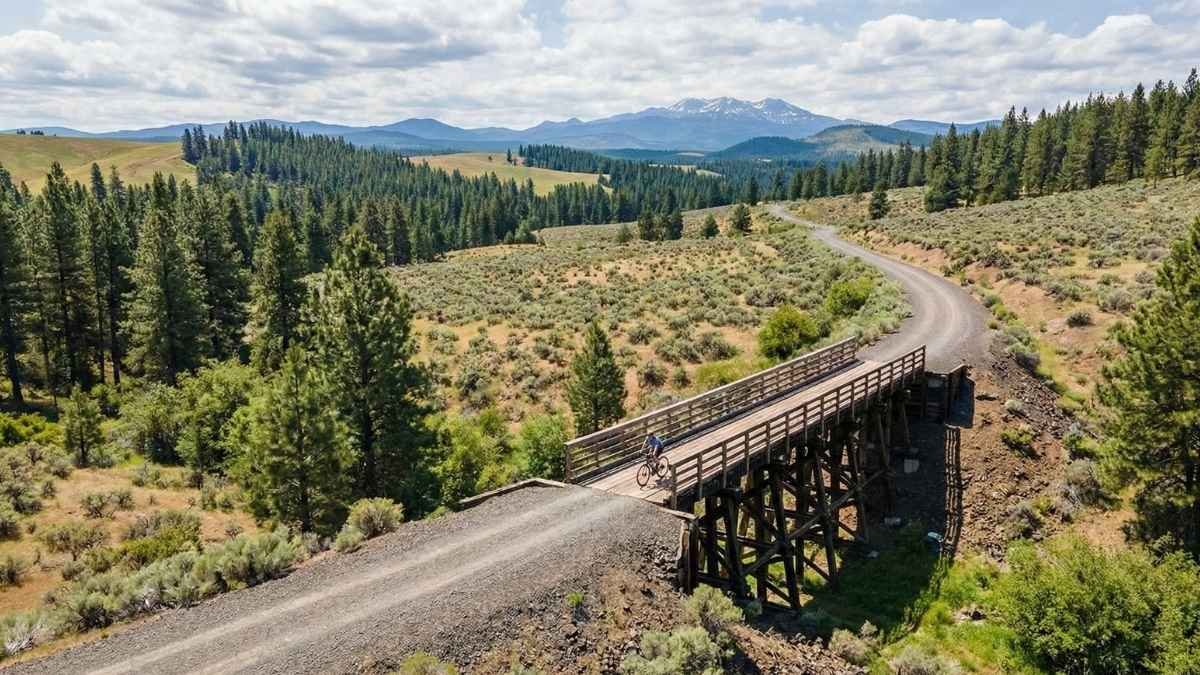
The Palouse to Cascades State Park Trail is one of the most diverse rail‑trail experiences in America. It follows roughly 250+ miles of the old Milwaukee Road corridor — from cedar‑shaded forests in the Cascades to sun‑drenched shrub‑steppe landscapes in central Washington. Along the way, hikers encounter long railroad tunnels, high trestles, basalt cliffs, wide‑open farmlands, and lakeside paths that feel like a cross‑section of the Pacific Northwest itself. Washington State Parks+1
One of the most memorable segments for hikers is the Snoqualmie Tunnel passage, where the trail goes underground for over 2 miles with only bike lights to guide the way — an eerie yet thrilling experience that few other trails offer. The variety here keeps you guessing; one moment you’re threading through alpine foothills, and the next you’re skirting expansive wheat fields peppered with wildflowers. Washington State Parks
Because the trail is long and split into different sections, it’s ideal for choosing a portion that matches your energy and interests. Some areas are rustic or even require detours, so a bit of planning goes a long way — but that only adds to the sense of adventure. Watching the landscape shift dramatically as you cross the state is something I always find surprisingly moving. Washington State Parks
Quick Facts & Tips:
- Best Months to Visit: Late spring–early fall (winter snow closes the Snoqualmie Tunnel Nov–May)
- Trail Length: ~251 miles (varied sections)
- Difficulty: Easy overall, but long distances can challenge endurance
- Surface: Gravel/light gravel
- Historic Features: Snoqualmie Tunnel, trestles, old depots
- Notes: Check closures and section maps before planning due to post‑washouts/ongoing repairs
3. Katy Trail State Park — Missouri

If there’s one rail trail synonymous with American adventure, it’s the Katy Trail State Park. Stretching across the heart of Missouri, this path follows the old Missouri‑Kansas‑Texas Railroad (MKT) bed and links charming small towns with miles of uninterrupted, gentle trail. The surface — packed limestone makes this a super‑comfortable hike for all walkers. Grokipedia
As you head westward, the trail traverses rolling river valleys, open fields, and shady woodlands. Along the way, historic towns like Hermann and Clinton invite you to pause, grab a meal or a local wine, and soak in the tranquil small‑town vibe. Because the grade is flat and the trail straightforward, Found that Katy feels equally welcoming whether you’re on a multi‑day trek or just exploring a beautiful day‑hike segment. Grokipedia
The sheer simplicity of Katy’s landscape is part of its charm — the rhythm of your footsteps against the packed trail, the slow reveal of farmland vistas, and the occasional wildlife sighting make it feel timeless. It’s a route that’s easy to fall into rather than conquer, and that’s exactly why it’s beloved by hikers and cyclists alike. Grokipedia
Quick Facts & Tips:
- Best Months to Visit: Spring & fall for perfect temperatures
- Trail Length: ~237 miles
- Difficulty: Easy/flat
- Surface: Packed crushed limestone
- Best For: Beginners, long‑day hikes, town‑to‑town explorations
- Amenities: Trailheads are often near small towns with food & lodging
4. Trail of the Coeur d’Alenes — Idaho
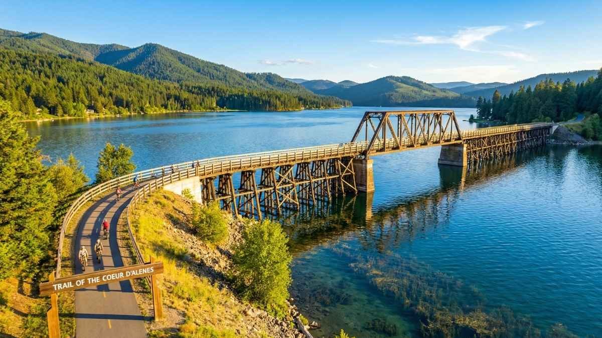
The Trail of the Coeur d’Alenes is a shining example of a rail trail that feels like a nature retreat rather than a conversion project. Built on the old Union Pacific Railroad corridor, this 73‑mile paved route sweeps from Mullan to Plummer across northern Idaho’s dramatic landscapes, hugging rivers and lakes and offering panoramic views at nearly every turn. Wikipedia
One of the trail’s standout features is the stretch over Lake Coeur d’Alene, where a restored wooden trestle and swing‑span bridge carry you out over shimmering water — truly one of those moments that makes hiking feel cinematic. With a smooth surface and gentle grade, it’s accessible to almost every hiker, walker, or wheelchair user, and the birding and wildlife opportunities are excellent year‑round. Wikipedia+1
Heard from hikers and local guides that this trail often feels like a discovery rather than a destination — you think you’re just walking, and then suddenly a bald eagle circles overhead, or you’re looking back at a mountain reflection so still it feels surreal. That blend of gentle accessibility and wild beauty is the Trail of the Coeur d’Alenes’ real magic. The Outbound
Quick Facts & Tips:
- Best Months to Visit: Late spring–fall for warm, dry weather
- Trail Length: ~73 miles
- Difficulty: Easy (flat paved surface)
- Surface: Asphalt
- Highlights: Lake trestle, river vistas, wildlife viewing
- Best For: Families, casual hikers, multi‑day strolls
5. Cowboy Trail — Nebraska
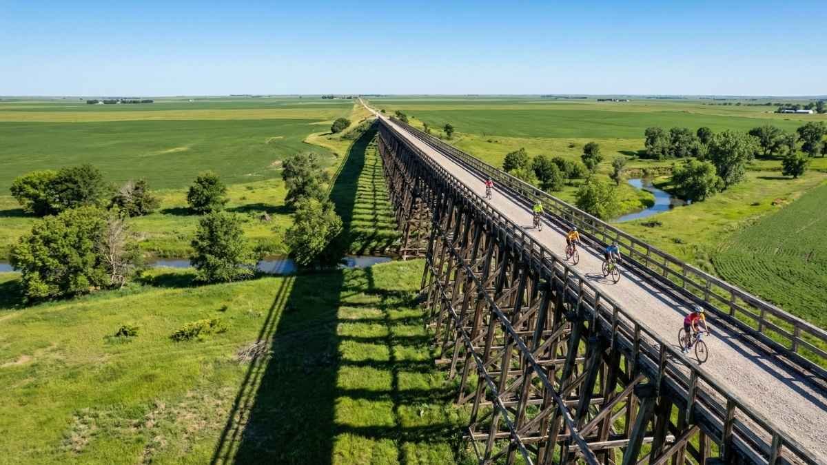
The Cowboy Trail is a slice of rustic Americana that spans northern Nebraska and holds the title as one of the longest rails‑to‑trails projects in the U.S. It follows the route of the old Chicago and North Western Railway, stretching toward 200+ miles of trail across grasslands, river valleys, and sleepy rural communities. Wikipedia
There’s a tangible sense of history here: old depots, restored bridges, and weathered mileposts still dot the route, and you really get a sense of how these rail lines once stitched the country together. Hikes here are less about high drama and more about quiet discovery — the wide Nebraska sky, the whisper of prairie grasses, and the slow rhythm of your own footsteps make it a deeply grounding experience. Wikipedia
Because the Cowboy is more remote, having your supplies planned — water, food, maybe a spare tube if you’re on a bike — makes the hike feel more self‑reliant. But it’s that very remoteness that keeps this trail on the “best” list. It’s like stepping back into a simpler era, with miles of open trail and enough space to let your thoughts wander as freely as the cattle once did. Wikipedia
Quick Facts & Tips:
- Best Months to Visit: Spring & fall to avoid summer heat
- Trail Length: ~195 miles (with extension plans ongoing)
- Difficulty: Easy/moderate
- Surface: Mostly crushed limestone
- Rural Amenities: Towns spaced 10–15 miles apart for rest stops
- Best For: Long‑distance hikers, solitude seekers
6. Elroy‑Sparta State Trail — Wisconsin
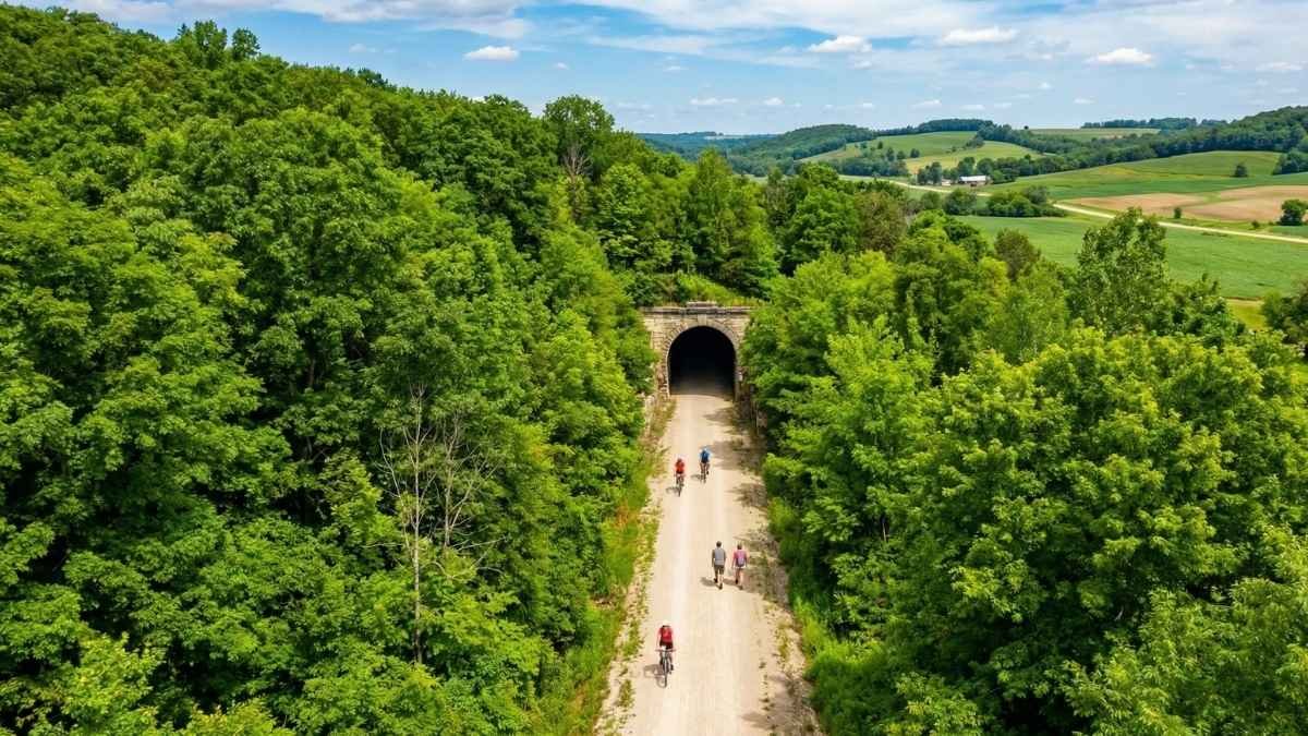
Picked as one of the earliest examples of “rails to trails” conversion in the United States, the Elroy‑Sparta State Trail carries with it a historic weight that few other trails can match. The route follows a 32.5‑mile stretch of abandoned Chicago and North Western Railway bed through the rolling Driftless Area of southwestern Wisconsin — terrain left untouched by glaciers that gives this corridor a unique mix of gentle hills, farmland, and shaded woodlands. More than just a walk in nature, it’s a journey through history, as the trail still includes the original tunnel entrances and railroad depots that once served steam locomotives here. Wisconsin DNR+1
The star attractions here are undoubtedly the three historic tunnels — each a testament to 19th‑century engineering. Tunnel 3, at 3/4 of a mile long, can feel like its own adventure deep beneath Wisconsin’s bluffs, while the smaller tunnels add layers to the experience. Whether you’re hiking or biking, you’ll want a headlamp or flashlight (and maybe even a light jacket) to fully enjoy these cool, echoing passages. Wisconsin DNR
Along the way, the trail links up with five small towns — Elroy, Kendall, Wilton, Norwalk, and Sparta — each offering chances to rest, eat, or explore local history. The surface itself is crushed limestone, making for a comfortable and accessible hike that’s perfect for a long day out or a multi‑day journey if you take your time with all the side stops. TrailLink
Quick Facts & Tips:
- Best Months to Visit: May–October (tunnels open; best trail conditions)
- Length: ~32.5 miles
- Surface: Crushed limestone
- Difficulty: Easy to moderate
- Trail Towns: Elroy, Kendall, Wilton, Norwalk, Sparta
- Must‑See: Historic railroad depots & tunnels
7. High Bridge Trail State Park — Virginia
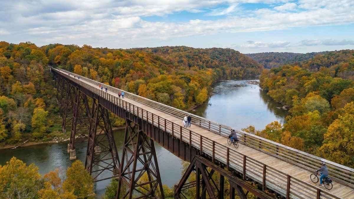
If there’s one rail‑to‑trail that literally takes your breath away, it’s the High Bridge Trail State Park — and not just because you’ll be hiking up to 125 feet above the Appomattox River on the historic High Bridge itself. This 30+ mile trail traverses former Norfolk Southern railroad land through rural Virginia woodlands and farmland, combining a compelling piece of Civil War‑era history with easy, scenic hiking and walking paths that are flat and friendly for visitors of all ages. Wikipedia
The bridge — once a critical link for trains and the site of fierce Civil War actions — is now the centerpiece of the experience. Strolling or hiking across its span gives you sweeping views of the river valley below and a sense of how these old rail routes once crossed great obstacles with sheer engineering resolve. For many hikers, this moment on the bridge becomes the highlight of their trail experience. Wikipedia
The trail’s crushed limestone surface makes for a comfortable walk, and because it’s essentially flat (thanks to its railroad origins), it’s a favorite for families, casual hikers, and bicyclists alike. Stop in Farmville — a charming college town nearby — for a meal or a cold drink before continuing your adventure. TrailLink
Quick Facts & Tips:
- Best Months to Visit: Spring–Fall (pleasant weather, bridge views)
- Length: ~30+ miles
- Surface: Crushed limestone
- Difficulty: Easy (flat grades)
- Highlight: Historic High Bridge crossing
- Nearby Town: Farmville, VA
8. Silver Comet Trail — Georgia & Alabama
For hikers who enjoy a long, paved, and consistently scenic route, the Silver Comet Trail stands out as one of the most beloved rail‑to‑trail paths in the Southeast. Originally part of the Seaboard Air Line Railroad serving passenger trains like the Silver Comet, today it stretches about 61.5 miles from Smyrna, GA to the Alabama state line — and once you connect it with the Chief Ladiga Trail, you’ve got nearly 95 miles of continuous rail‑to‑trail path. Wikipedia+1
What makes this trail so captivating is its mellow, accessible layout and variety of scenery. You’ll pass through pine forests, over bridges and trestles, by wetlands, and beside quaint towns where local cafes and rest spots make perfect mid‑hike breaks. And because it’s paved and mostly flat, it’s super friendly for hikers of all abilities — including folks pushing strollers or using wheelchairs. Cobb County
Along the way, look for the Brushy Mountain Tunnel (a favorite spot for photos) and plenty of trail‑side amenities like restrooms, benches, and interpretive signs. It’s one of those hikes that feels social and peaceful at the same time — great for burning half a day or even conquering end‑to‑end if you’re up for it. PATH Foundation
Quick Facts & Tips:
- Best Months to Visit: Year‑round (moderate climates)
- Length: ~61.5 miles (connects to Chief Ladiga Trail)
- Surface: Paved
- Difficulty: Easy
- Best For: Long hikes, family walks, photography spots
- Scenic Highlights: Bridges, tunnel, wetlands
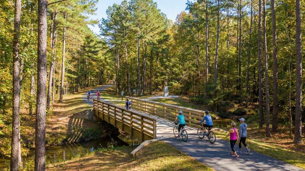
9. Farmington Canal Heritage Trail — Connecticut

The Farmington Canal Heritage Trail offers a delightful contrast to some of the longer wilderness paths on this list. Following the corridor of an abandoned railroad and canal system in Connecticut, this trail blends historic charm with approachable walking segments that are perfect for locals and travelers alike. While it’s shorter than some of the epic rail‑to‑trail routes, its paved sections and proximity to towns make it exceptionally versatile for all kinds of hikers — from early morning strollers to serious day explorers. DayTripper
What makes the Farmington Canal stand out is how it weaves through suburban parks, historic districts, and quiet rural stretches. You don’t have to devote a whole day to this hike; you can spend an engaging couple of hours tracing the old corridor, soaking up historical markers, and ducking into local cafes for refreshments at either end. DayTripper
Whether you’re a history buff or just enjoy a scenic stroll that feels connected to the rhythm of community life, this trail’s mix of natural views and human‑scale stops makes it a perennial favorite in the Northeast. DayTripper
Quick Facts & Tips:
- Best Months to Visit: Spring–Fall (milder temps)
- Length: Varies (connected sections)
- Surface: Paved
- Difficulty: Easy
- Best For: Casual hikers, families, town‑to‑town walks
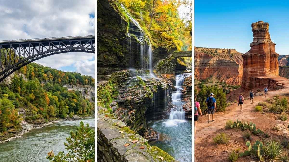
10. Empire State Trail — New York

Closing out the list with an epic adventure, the Empire State Trail isn’t just one trail — it’s a network that connects hundreds of miles of former rail corridors, canal paths, and scenic walkways from New York City up to the Canadian border and west to Buffalo. At about 750 miles in total, this route is one of the most ambitious rail‑to‑rail trail experiences in the U.S., offering a massive variety in landscapes, cultures, and outdoor experiences. Empire State Trail
You’ll find flat, forgiving paths perfect for long‑distance hikers and multi‑day trekking, alongside urban segments that pass historic neighborhoods and waterfronts. Its value comes from how it connects places — canal towns, river valleys, forested sections, and big cities — all using corridors that once carried trains and later served industry and growth. It’s a monumental way to see New York on foot. Empire State Trail
Whether you’re knocking out a single segment or planning a serious long‑haul hike, the Empire State Trail’s sheer scale and variety make it a bucket‑list choice for rail‑to‑trail fans everywhere. Empire State Trail
Quick Facts & Tips:
- Best Months to Visit: Spring–Fall (best overall weather)
- Length: ~750 miles (network)
- Surface: Paved & crushed stone (varies)
- Difficulty: Easy to moderate (section dependent)
- Best For: Long‑distance hikers, thru‑hikes, trail networks
- Connects: NYC → Hudson Valley → Erie Canal → Adirondacks/Buffalo